Animated sendai map before the quake and the after. [*love & life]
NASA released their satellite view of Sendai,
and I made the Animation for the comparison.
This Image was captured at February 26, 2011 and March 12, 2011.
You see the devastating grand erosion by the quake and tsunami.
Now Rescue teams is coming from around the world,
and a lot of the victims are taking off by them from the new gulf.
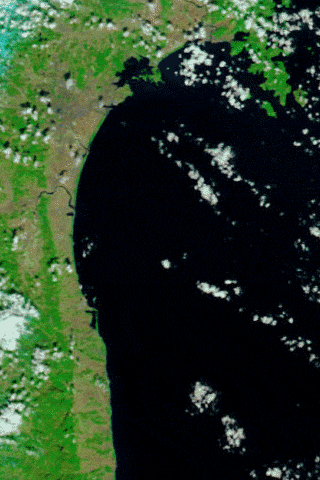
Flooding from Tsunami near Sendai, Japan : NASA
http://www.nasa.gov/multimedia/imagegallery/image_feature_1892.html
and I made the Animation for the comparison.
This Image was captured at February 26, 2011 and March 12, 2011.
You see the devastating grand erosion by the quake and tsunami.
Now Rescue teams is coming from around the world,
and a lot of the victims are taking off by them from the new gulf.
Flooding from Tsunami near Sendai, Japan : NASA
http://www.nasa.gov/multimedia/imagegallery/image_feature_1892.html

